Geology
GEOLOGICAL ROCK AND ROLL AT GLENORCHY
Glenorchy Township occupies a low-relief fan, constructed in recent times by the Buckler Burn, and minor streams draining proximal slopes. The accumulation process has been aided by longshore drift at former elevated lake levels. Flanking Glenorchy to the north is the Dart/Rees River delta complex, a broad area over which there is an ongoing build-up of sediment. This generates a migrating delta front, which is clearly shifting over time in relation to the fan fringe. At depth, beneath the township, the fan alluvium will have an increasing fineness, largely due to the accumulation of silt-sized material, deposited in the lake by the principal rivers when the deltas were further up valley.
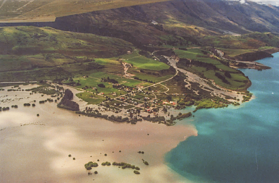
The present terrain is young, in a geological sense, having only evolved since the capture of the former high level (post-glacial) Lake Wakatipu by the Kawarau River, at a point east of Frankton, at an estimate time 7,000 years before the present. This event resulted in a drainage switch from the Mataura to the Clutha catchment, and an approximate drop in lake level of 50m.
Evidence for such a change is well developed near Glenorchy, where the higher-level deltaic remnants flanking the lower Buckler Burn drop to the level of the present fan. The staged, intermediate-level benches on the north-facing slope in particular are well developed, and were instrumental in coining the term “The Bible” for the local terrace remnant, as they looked like the page margins of a skewed book. Older terrace formations extend south to the airport and there is a prominent, wave-cut bench at the former lake level height, which extends to the north; locally traversed by the main road. Note the upper level evidence for a former Lake Wakatipu shoreline in the Glenorchy region is about 10m higher than equivalent features in the Queenstown – Frankton area. A significant, ongoing uplift of the land near the head of the lake is implied over the last (speculative) 7,000 years, a concept supported by random, shallow-crustal earthquake activity in the mountainous terrain.

Landform and geological changes in the Glenorchy region have been routine. Of particular interest is the sculpturing developed during the many glacial advances, which have occurred during the present ice age, i.e. the last 2.6 million years. Major advances will have had glacial crests near Glenorchy at about 1600m above sea level; highlighted on the valley walls by such features as accordance of truncated spurs and distinct profile changes. Sculpturing by the last intruding glacier, some 18,000 years ago, is harder to uniquely discern, but there is reliable evidence for a maximum crest level near Glenorchy at 650m above sea level, or 340m above the present lake.
The Wakatipu headwaters region is dominated by mountains rising to 2830m above sea level (Mt Earnslaw). The elevation of this terrain is a geologically recent phenomenon, and relates to the Kaikoura Orogeny, a crustal mountain building phase, which only commenced in the area about 5 million years ago. Prior to that the general relief across Otago was low, with subdued schist uplands contributing fine sediment to an evolving depression occupied by the former, widespread Lake Manuherikia in the Miocene geological period (24 to 5.3 million years before present). While the western margin of this lake had a speculative position, it most likely did not impinge upon the Glenorchy site, an assumed slightly proud terrain at this time. And there is a recent debate regarding the degree of marine inundation of the pre-existing New Zealand landmass in the Oligocene period (34-24 million years ago). Marine sediments of this age are preserved at Bob’s Cove and there is an infaulted, fossiliferous strip in the schist mountains just 15km to the east of Glenorchy, so it is likely that the site of the township was similarly under the seas some 30 million years before the present. This interpretation, however, does not imply that the whole of Otago was inundated; there is some evidence to the contrary.
Bedrock at Glenorchy is schist,a metamorphosed marine sediment originally deposited on the fringe of Gondwanaland some 220 million years ago. Its subsequent deep burial changed the composition and textures of the component rocks, and there have been subsequent phases of tectonism, resulting in the development of faults, folds and the transposition of various lithological boundaries. Fracture systems have allowed the upwards migration of deep-seated, siliceous fluids, containing minor amounts of gold and scheelite. The fluids precipitated under decreased pressure and temperature, resulting in quartz lodes of various dimensions and persistences, many of which are visible at the surface in a dissected landscape.
Glenorchy is locally famous as a mining centre due to both the lode presences and the gold bearing detritus shed off them over time.
Article by Royden Thomson, Geologist, Cromwell